Day 1:
8:30am bus from Invercargill to Bluff, meeting the 9:30am ferry. Not too rough.
Met a Japanese tramper from Queenstown, Eiji, who is doing the NW circuit
clockwise as well. Also Darren who is going anti-clockwise. Brief stop at DOC
centre before setting off at 11:10am. Packs approximately 17kg each. Half an
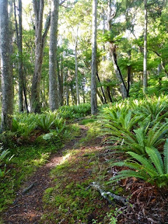
hour or so along Main Road (gravel) to start of the Rakiura Track at Fern
Gully. Very easy grade, gravel with a few small patches of mud. Nice views of
Paterson Inlet in places. High cloud, not much wind. 2:40 hours to Sawdust Bay
campsite and another hour to North Arm Hut. 6 others staying the night. One
couple just finishing the NWC. Took them 7 hours from Freshwater Hut. Full
moon, bright night. Saw a deer by woodpile. Bed at 9:30pm.
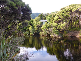 |
| Freshwater Hut |
Day 2: Up
at 7am – not light yet. Ended up carrying the 2nd billy as well as 2
meals which L had been carrying, so now I have all the group gear except 2
dinners. Set off at 8:20am. Track got muddy immediately, undulating around the
coastline for 2 ½ hours before heading up Thomson Ridge. Got rootier and
muddier but we could clamber around most of it. L was slower on the tricky
parts. Topped out 4 hours after leaving hut. Wet and muddy descent to begin
with – seemed to be going down a stream – then it became a decent track, but
still muddy. Reached Freshwater Hut in 6:40 hours, stopping roughly 10 minutes
every hour. Weather was overcast but warm all day.
Lots of bellbirds,
tomtits, tuis, a few wood pigeons, and a couple of red crowned parakeets. The
hut has a resident tui and a pair of Stewart Island robins. The latter are
hopping around nearby pecking the sandflies off my feet as I sit outside on the
deck. There is another NZ guy, Alec, here who got dropped off by boat this
afternoon – we heard the boat go past about 1.5km from the hut. Eiji has
carried on to Mason Bay. Alec made a small campfire to cook tea as he had opted
not to carry a cooker. L & I joined him and boiled our billy on the fire as
well. Alec is a keen birdwatcher and is here looking for the South Island
Kokako (or Grey Ghost). Heard kaka and kiwi.
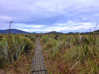 |
| Chocolate swamp |
Day 3:
Lazy morning. Lay in bed until 8am. Light drizzle which cleared up by the time we
left at 9:20am. Very flat track through the Freshwater flats but interesting
variety of surroundings. Not too muddy. Lots of birds – saw a pair of kakariki.
Lots of kiwi footprints. Glad of the boardwalk through Chocolate Swamp! The
stream we walked beside from Freshwater was interesting – quite rapid and noisy
despite having very little fall. Investigated the historic homestead, woolshed,
& hunters hut near Mason Bay. 4 ½ hours to Mason Bay hut. Feet a little tired.
Nice spacious hut tucked in on the edge of big sandhills. Strolled out to the
beach barefoot – a lot further than expected (approx 10 min). Very picturesque.
Could see the South Island in the distance behind Codfish Island. Watched the
sunset from sand dune beside hut.
We were toasting
marshmallows in the wood burner when a kiwi called nearby. Rushed outside and
there was a pair of kiwi beside the track to the toilet! They wandered across
the main track and one came to investigate us, approaching to within a metre
before heading into the bush. Not worried by us or our lights at all.
 |
| North end of Mason Bay |
Day 4: Up
at 6:30am. Red sunrise. Off at 8am. Started raining as we put our packs on. Saw a plane fly down to
Mason Bay – it took off again as we reached the beach. Pleasant walk along the
beach and the rain eased up. 1:35 hours to northern end of Mason Bay. Pretty
much low tide but we still had to time the waves around one small rock outcrop.
Very muddy & steep track up from beach! 1 hour to top. Not too bad down the
other side to Little Hellfire Beach. Rain was pelting down as we walked along
the beach. North end of beach 2 hours after leaving Mason Bay. Rain stopped
around noon. Long climb up to the ridge but not too steep. Saw a kiwi poking
around in the bush beside the track at 300m, and another one just before point
399. Sun came out at 2:30pm and wind got up strongly. Was warm this morning but
cooled down when the wind got up. 7 ½ hours to Big Hellfire Hut. Eiji was staying
2 nights here so we met up with him again. Spent 2 hours trying to get the wood
burner going but to no avail as the wood was all damp.
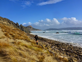
 |
Let the mud begin!
Climbing out of Mason Bay |
Day 5: Up
at 7am. Went out to sand dune to watch sun come up. Wind had died down. Saw a
kiwi 30 minutes from hut. 2 hours to Waituna Bay. Rain started just after 9am
but eased off by noon. Another 1:36 hours to Ruggedy Pass, and 2:13 hours down
to West Ruggedy Beach. Tracks were a bit muddy. Tiptoeing around the mud added
extra time. Saw a white tail deer. Tide was high when we reached West Ruggedy
and waves were coming just about up to the sand dunes. Lots of driftwood. L got
caught by a rouge wave. Took high route over bluff – extremely windy and hard
to stand! Got sandblasted as we left the beach (1:10 hours along beach).
Reached East Ruggedy Hut in 7:45 hours.
Highlight of the day was
finding fresh carrots in the hut! Darren was already there and had been given
some venison by hunters so he fried it up and shared it with us. Pleasant
evening inside but very windy outside.
 |
| West Ruggedy Beach |
Day 6:
Strong winds, heavy rain, hail showers overnight. Also a couple of loud
thunderclaps which shook the hut. Lazy start as we were hoping the weather
would improve a bit. Hail shower as we laced up. East Ruggedy Stream crossing
was knee high. Just as well it was low tide! Wore longs & overtrousers.
Much colder than it has been the last few days. Solid climb up and over to
rocky coast. Low tide but big swells, so waves were crashing up onto the
boulders. Only had to time around one small outcrop. Short hail shower. 30
minutes along coast. Very steep climb out. Met a hunter 20 minutes before Long
Harry Bay – they have a very well appointed campsite beside the track. Could
see the hut from point at west end of bay but took another 1 ½ hours to reach
it. Several steep, slippery climbs in and out of streams. 5:10 hours from East
Ruggedy hut to Long Harry Hut. The hut sits up on a headland looking NW. Very
windy! Heavy hail shower just after we arrived. Hut shakes in the wind and
chimney squeaks loudly.
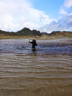 |
| Crossing East Ruggedy Stream |
Day 7:
Lazy start. Not as cold as yesterday. Warmed up quickly going uphill so soon
stripped off a bit. Crossed river at west end of Smoky Beach – only ankle deep.
Delightful beach! Not much wind, low tide, golden sand. Near the eastern end
met 3 trampers heading the other way. Rain set in. Track inland was not very
well marked but we had fresh footprints to follow. Another hill, this time a
bit muddier. Rain all the way to Yankee River Hut. 4:05 hours. Only 9°C outside
(didn’t get past 10°C). Two hunters were in residence and had shot a deer
yesterday – it was hanging on the deck. Heard yellow-eyed penguins across the
river about 4pm. Interesting to watch the river – tidal waves surge upstream as
the tide comes in. Fire going, radio on, word puzzles; pleasant afternoon.
 |
| Unusually dry piece of track |
Day 8: Up
just after 7am. Nice orange sky so went out to beach briefly. Back out to watch
the sun rise over the horizon after breakfast. Tranquil. Day turned out sunny
with blue skies but we were in bush the whole way. The only steep climb was
immediately after leaving Yankee River. Stopped at Lucky Beach to have a quick
scout for paua but no success. 2:40 hours to eastern end of Lucky Beach. Track
gradually got drier under foot. Some parts were lovely and dry but there were
still plenty of mud holes. Lots of little streams whose water tasted delicious
and was not discoloured by tannin. Tried eating a miro berry but it didn’t
taste very nice and there wasn’t much flesh. 3 hours from Lucky Beach to Mt
Anglem turn off. Eiji’s pack was there as he dashed up to the summit. Reached
Christmas Village Hut in 5:53 hours from Yankee River. The hut is right on the
shoreline. Feel hungry as I haven’t eaten enough the last couple of days
(trying to make sure we don’t run out of food).
 |
| Sunrise up Mt Anglem |
Day 9: I
got up at 6:15am and set off at 6:35am to climb Mt Anglem by myself. L would
walk on to Bungaree hut by herself. Extremely intense, red sunrise. Got to
watch it as I ascended. Track was very rooty, muddy and steep. Much worse than
any of the other tracks. I really enjoyed walking the first hour in the dark.
Saw a kiwi at 300m (7:20am). Some knee-deep mud holes. Cold wind on top. 2:15 hours
to summit. Got a good view. Started raining lightly when I reached the bushline
on my descent. Got back to Christmas Village in 4:25 hours, pushing hard all
the way. 980m climb, 10km. Quickly ate lunch and packed up then set off for
Bungaree Hut at 11:30am. Lots of bush and the track gradually got muddier. Legs
are rather grubby! Lots of boardwalk into
Murray Beach. Solid rain by now. It was lovely walking along the beach in the
rain by myself. 2:16 hours to beach. My right knee suddenly got sore climbing
out. Slowly got better but didn’t come completely right. Heard kaka and saw a
deer 20 minutes before the hut. 4 hours to Bungaree Hut from Christmas Village.
L & 3 tourists were in residence. Annie found some flour in the hut so made
mini pizzas on the top of the wood burner. Absolutely delicious! Nice to have
fresh baking.
 |
| Deserted Murrays Beach |
Day 10:
Yet another lazy start. 2:44 hours through to Port William Hut. Big (and deep!)
bog holes in the last section. Had planned to stay here but a DOC working party
was in residence with their generator and lots of gear so we decided to carry
on out to Oban. Another 3 hours on the gravel Rakiura Track and roads back to
Halfmoon Bay. Civilization!
 |
Maori Bay
Last beach for the trip. |
I thoroughly enjoyed tramping on Stewart Island and would
recommend the North West Circuit. As long as you expect mud and some hard days
it will be fun. It would definitely pay to check the tides beforehand. Getting
a water taxi / plane to Freshwater / Mason bay would save a couple of less
interesting days. Already I want to go back again!

 The clear sky was brilliantly orange to the east as we set off from Blyth Hut at 5am. Three hours of walking up the volcanic boulder fields brought us to the snowline on the south face of Girdlestone (2658m), where it was time to gear up with crampons, ice axe, harness and helmet. A steady plod up gradually steepening snow for a while before the ropes were hauled out. The conditions were great for cramponing, each foot biting firmly into the snow.


