It was 0°C when I set off mid-morning from the Aniseed Valley car park in the Richmond Ranges. Pretty cold for the first couple of kilometres along Hacket Creek! (Later I heard this section referred to as "Polar Mile"). I was wearing shorts and my quads were soon red and numb. It took 1 1/2 hours to reach Hacket Hut, which was serenely situated in a sunny clearing. After a quick break it was 30 minutes and 8 river crossings up Hacket Creek, all of which I managed to tiptoe across with dry feet, before beginning the relentless 900m climb. My pack felt pretty heavy! I chugged up the hill steadily; there was no rush and I had the world to myself.
I popped out at Starveall Hut after 4:40 hours and 1,140m of ascent. A hunter (Phil) and his dog (Molly) were already in residence but there was plenty of space to spare in the cosy 6 bunk hut. The tap had broken off the water tank so I had to climb up on top and scoop water out with a billy into a 20L container. Nearby Pt 1258 provided a spectacular vantage point with panoramic views of Mt Rintoul, Abel Tasman and the Arthur Range. There was not a breath of wind so I spent well over an hour soaking up the serenity. Returning to the hut for a hot soup, I was soon back out to watch the brilliant orange sun slowly sink behind the silhouetted shoulder of Mt Arthur. The evening was spent sitting in front of the fire spinning yarns. Phil regaled me with hunting stories and tales of his time trekking in Nepal.
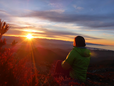 |
| Sunset behind Mt Arthur |
Watched the sunrise then headed over Mt Starveall (1,511m) to Slaty Hut. There was a bit of powdery snow around on the tops which was good fun. There was no time pressure as I had all day to fill in so I took my time and had plenty of stops. Two hours through to Slaty Hut, and then I carried on along the track and popped up to Slaty Peak (1,544m). I lingered here in the sunshine for a while before deciding that it was time to get a move on as cloud was spilling over Starveall. Instead of backtracking I continued north then east along the ridge to pick up the track where it entered the bush. The temperature dropped a bit once I entered the cloud, but there was no wind so it was actually quite pleasant. Picking my way down rocks coming off Mt Starveall my foot slipped and I took a small chunk of skin off my hand - nothing a plaster couldn't fix. It was still early in the afternoon when I arrived back at Starveall Hut so I spent a while mucking around gathering firewood etc. There was a pile of logs where a tree had been cleared down the bank so I lugged those up to the wood shed. Cloud came in even thicker at 3:30pm with light showers and a few pellets of hail; the temperature plummeted to 4°C. I was alone for the night, basking in the warmth of the fire.
 |
| Slaty Peak |
Woke up refreshed after a good long sleep. Packed up efficiently and lugged more firewood to the woodshed before setting off down the hill. The hut was in cloud but I soon dropped down below. I moved steadily, only stopping for photography. For over a kilometre a friendly fantail kept me company, darting around my legs and often approaching within a few inches. He left me at the second to last river crossing. It took 2 hours to reach Hacket Creek and then another half hour through to Hacket Hut. Once again I managed to tiptoe my way across all 8 stream crossings with dry feet. All that remained was a pleasant stroll out to the car park.
 |
| Starveall Hutt |
Map
I couldn't trace the origin of the name Starveall in the region, but it seems to be a common English farm name implying poor land which is certainly apt.


