Saturday, October 27, 2018

Eyre Excursion

“Summer is here!” There was no denying this statement as we toiled up yet another bump on the ridge beneath a merciless sun. The eastern ranges of Otago’s Eyre Mountains are dry at the best of times, but with not a puff of wind or wisp of cloud to take the edge off the beating sun, the midday heat was relentless. 

The ridgeline of day 2, traversed from right to left.

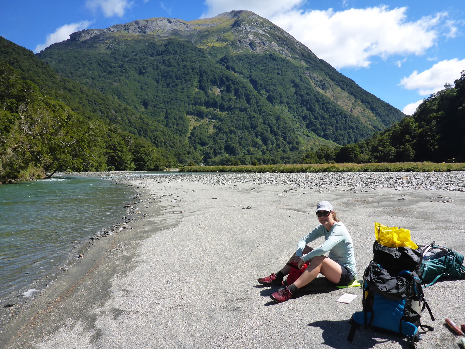
The route had looked easy on the map: a couple of hours beside Irthing Stream to Mansion Hut the first night; straightforward, undulating ridge travel to Irthing Hut, and then a couple more days alternating between valley tracks and open tops, taking in Upper Cromel and Islands Huts, to complete the circuit. But now that seemingly easy ridge threatened to get the best of us.

The first day had gone to plan with a delightful meander up the valley to the tiny, humourously-named two-bunk Mansion Hut. There was not much living space inside so we opted to enjoy the calm, clear evening and soon had the campfire blazing outside. 

Mansion Hut

Brendan had gleefully promised lots of treats and surprises for my birthday and true to form he whipped up a delicious breakfast of pancakes with fresh strawberries and maple syrup! This was to be but the first of many little celebrations throughout the day. With bellies satisfied we waded across Irthing Stream and made our way up the spur immediately opposite the hut. The beech forest was relatively open so the going wasn’t too bad, although steep, and it only took about an hour to reach the bush line. Emerging into the open there was a bit of scrub to push through at first, before giving way to tussock and low shrubs. Point 1260, the first of five high points along the ridge, was soon reached only for us to immediately drop and regain 150m to the next peak. 

While munching on fairy bread for lunch (after all, “What would a birthday be without fairy bread?”) it became apparent that the relentless heat was taking its toll on us. We were both wilting, and before us lay the daunting looking 450m haul up to Pt 1450. Beginning on the climb, the first warning signs of heat exhaustion began to loom threateningly. The tiny shadow of a large rock presented a brief respite before I haltingly continued upward through the knee-high shrubs. The route itself was not tricky, but what had promised to be a nice ridge walk was turning into a real struggle. Brendan jubilantly found a lingering patch of snow which we put to good use in topping up water bottles and cooling ourselves down, shoving handfuls down our backs and under our hats. Still the climb went on and the sun beat down. A small bluff provided just enough shade for us to collapse in for half an hour before tackling the final 100m. Although we were still not at the highest point on the ridge, reaching Pt 1460 was a huge relief, both physically and mentally, as from here the gradient was much gentler and there was snow to provide a bit of cooling. 

Descending to Shepherd Saddle

After a brief break on the summit of Pt 1552 it was a straightforward descent to Shepherd Saddle, with a couple of small snow patches providing easy progress. From the saddle a nice scree shute dropped us 100m and then it was a descending traverse through tussock and shrubs down to the creek. What bliss to finally reach ice-cold, running water again! Half an hour through beech trees brought us out behind the bright orange Irthing Hut. According to the records in the hut book, only 12 people a year stay at this cosy two-bunk biv. A refreshing wash in the stream was first priority, and then Brendan proudly produced a bottle of sparkling grape juice! Just the ticket after a long, hot day in the open! We’d covered a mere 12.5km but had climbed over 2,000m. To complete the birthday celebrations Brendan decorated the hut with balloons and lit birthday candles on top of a steamed pudding. 

Irthing Hut
Stiff, weary bodies were still feeling the effects of dehydration the next day so it wasn’t until mid morning that we finally crawled out of bed. Originally the plan had been to head to Upper Cromel Hut and then over the tops to Islands Hut, but by the time we reached the Cromel Stream junction the decision had been made to take it easy and cut down to the nearby Cromel Branch Hut instead. The track over the low bush saddle between Irthing and Cromel was nice and interesting; re-marked and cut last year it was easy to follow despite some recent windfall. Cromel Branch Hut is nicely situated on a (slightly swampy) river terrace with firewood in abundance. Unfortunately the sandflies were also in abundance and we soon retreated inside. With plenty of time on his hands Brendan decided to knock up a seat out of old planks, a log, and some rusty wire and nails.

Feeling much refreshed after a good sleep we tramped back along the clearing to the Cromel Stream forks and then straight up the spur to Pt 1203 on Bee Ridge. The bush was steep but clear and we zigzagged up old deer trails. Once above the bushline there was a band of thick, head-high scrub to fight through to gain open rocky clearings. We spooked a deer and watched it bounding down the slope to shelter. Two hours after leaving the hut we crested Bee Ridge and joined the old 4WD track. From here it was a cruisy walk south to the Mount Bee Bunkrooms, with great views in all directions. This hut is quite unique, built from tongue and groove cladding, and is more reminiscent of a 1950s bach than a tramping hut. A relaxed afternoon ensued, lazing on the lawn and rehydrating with plenty of hot drinks.

Mt Bee Bunkrooms

“No way!” I rolled over in bed to look out the window to discover that it was snowing! Brendan sprang out of bed like a little kid with a beaming smile on his face and rushed out to enjoy the experience. We sat eating breakfast mesmerised by the whirling flakes. Although wet and heavy, the snow was settling on the ground. Two days ago we had been suffering from heat exhaustion, and now it was snowing. By 10am the snow had stopped so we quickly packed up and set off toward Irthing Stream via the spur just north of the hut. The tussock and scrub was all dusted with snow so we were soon completely drenched, but the bush was mostly fairly open and easy going although it still took two and a half hours to reach the stream. Back on the main track, a brisk pace was set as we tried to warm up. Walking the last section of gravel 4WD track from the campsite in light drizzle we reflected on what had been an enjoyable, yet under-estimated, tramp in a little-known part of the country. With unfinished business and so many other routes that caught our eyes along the way, another excursion into the Eyre Mountains is definitely in order.

Leaving Bee Ridge

Saturday, September 22, 2018

Mt Rolleston

3:20am Headlights on as Dad and I begin wandering up the Otira Valley under a sky glistening with stars, the surrounding mountains faintly glowing in the moonlight.

4:50am Crampons donned at the base of the Otira Slide.

6:50am The first rays of sunlight stream onto our faces as we crest the col at the top of Goldney Ridge after a long, calf-destroying climb up the firm couloir.

7:50am Time for a second breakfast on the Low Peak of Rolleston (2212m) to replenish energy levels.

9:00am A short step of ice and snow-covered rock has me asking for the rope.

9:30am We break out the celebratory chocolate on the summit of Mt Rolleston (2275m). It’s rush hour - two other trios arrive before we head back down. With not a wisp of cloud and nary a breath of wind we take our time to enjoy the views.

11:15am A leisurely lunch on Low Peak before descending the sun-softened slopes.

12:00pm The snow is very soft, with each step plunging us in up to our knees (occasionally floundering up to the hip), so we resort to bum-sliding. Even this proves difficult except in the path of previous sliders.

2:00pm We linger beside the bridge across the infant Otira River, reluctant to leave the mountains behind.

3:20pm Relief as boots are removed at the car park after a thoroughly satisfying day.


Dawn on the Otira Slide

On the Low Peak of Rolleston, with the High Peak behind

Descending the Otira Slide

Tuesday, June 12, 2018

Moonlight & Roses

“I think that’s our track.”

Two bluffs rose imposingly above the road along Lake Hawea and a line was visible zigzagging up the steep face between them before disappearing into the cloud. No gentle warm up here! From the car park up to Breast Hill is a climb of 1200m in about 6km. We settled into low gear and began steadily plodding upwards, soon stripping down to base layers. 300m up, at the top of the first face, we met two descending trampers who unbeknownst to us would be the last people we saw for 72 hours.

We crunched along the frosty narrow ridge, ever climbing through the cloud, until at last emerging above the inversion layer. A whole new world lay unveiled before us. To the west an unbroken chain of majestic snowy peaks filled the horizon. On the cloud below us danced a brocken spectre, and above us the ridge climbed even higher before meeting with the gloriously blue sky.

A brief detour to investigate the well-insulated but fireless Pakituhi Hut before swinging northward to Breast Hill. The snow started in earnest now, often being knee deep, but fresh boot prints to the summit made the going fairly easy. The snow was extremely light and fluffy so our crampons and ice axes remained superfluous weight on our packs. Oh well, better to be prepared.

 
Several kilometres of untrodden snow lay between us and our bed for the night, Stodys Hut. Occasionally when stumbling through a deep patch I almost wished I was wearing longs. We were still plodding along the tops when the sun sank below the mountains and the horizon was painted with pastel pink and purple. The last light was fading as we dropped down the track to Stodys Hut. In what was to become a nightly ritual, the very first task was to gather plenty of wood for a roaring fire.

At first light we were off again, dropping 500m straight down to the Timaru River, where the valley was white with frost. We followed the track downstream for 3km through bush and across grassy terraces until being spat out on the gravel river flats. From here on we were venturing into untracked terrain. Let the adventure begin! Immediately we were faced with the first of countless stream crossings; only shin deep but icy. Once the feet were numb it was quite pleasant splashing down the river bed as it gradually became more confined. After an hour and a half it was time to turn up the side stream leading toward Moonlight & Roses Hut. On modern topo maps this creek is unnamed, but historically it was called Deer Spur Creek (in conflict with the current naming of the neighbouring stream). The next two hours of stream bashing were freezing but fun! The first hour was spent almost constantly wading across or through the stream before reaching the more open flats halfway up the valley. With hoar frost on the banks and icicles hanging from wet boulders it was a beautiful, albeit chilly, place. Thankfully there was not too much ice coating the rocks to make the going treacherous.

 
Upon reaching the point where Moir’s Guide said to leave the stream a steep, slightly sketchy scramble up a frozen scree bank took us onto easy deer trails up the spur. Emerging above the bushline the stand of trees we were heading for was visible, although Moonlight & Roses Hut was tucked well out of sight. A few hundred metres of traversing around the slope soon had us stomping through the snow to the door. Moonlight & Roses is owned by Dingle Burn Station but is open for public use, although according to the hut book there are fewer than 10 visits per year (and the hut book goes back to the early 1980’s!). Firewood was in abundance so we had fun gathering more than enough to keep the fire blazing well into the night. I propped my feet up on the hearth to thaw them out, only to discover later that I managed to scorch holes in my socks – while wearing them!

Moonlight & Roses Hut
Overnight the temperature inside the hut dropped below -3°C so frozen boots had to be thawed by the fire in the morning before putting them on. A stiff 300m climb through snow up to the saddle was a tough way to start the day but the view from the top was an excellent reward, and we spent a good quarter of an hour sitting in the sun soaking up the scenery. Dingle Peak loomed large above us with an alluring ridgeline. That will have to wait for another time when snow conditions are more favourable. Descending into Junction Creek (called Deer Spur Creek on the topo maps) we were soon in the shade and as we ploughed down through deep snow I once again found myself wishing that I was wearing longs. The route down the stream was surprisingly easy and we barely got our feet wet crisscrossing the creek. However we had to be very cautious as there was ice coating the rocks along the stream. At one point we sidled high to avoid a waterfall but a poor judgement call saw us tentatively clawing our way down a frozen shingle slide. Not the smartest decision of the weekend. The sun was still shining when we popped out onto the bottom river flat so despite being merely minutes away from Junction Hut we stopped to boil the billy and have a picnic.

Junction Hut

Being more accessible and more frequented, the firewood supply at Junction Hut was a lot more scarce than the previous nights. Nevertheless we managed to source enough wood for two nights (although we were only staying for one). The temperature profile inside the hut that night was quite steep: 25°C where we sat in front of the fireplace, 8°C a metre back, and 0°C and the far end of the hut. The hut book had many comments about resident mice so it was no surprise to hear rustling in the corner by my pack. A bold wee mouse kept coming out to investigate so we set a couple of traps under the bunks. Sure enough, half an hour later the population decreased by one and we were not bothered for the rest of the night.

Our last morning was very relaxed as we didn’t have far to go. An hour of brisk walking down the Timaru River track, with a few swift crossings, saw us to the road bridge. From here it was a gentle 6km stroll along the gravel road to complete the loop.

Who would have thought you could have huts to yourself on a long weekend within an hour’s drive of one of New Zealand’s most outdoorsy towns!


Times:
Car park -> Pakituhi Hut 3:15 hours
Pakituhi Hut -> Stodys Hut 4:15 hours
Stodys Hut -> Timaru River Track junction 1:10 hours
Track junction -> Bottom of Deer Spur Creek 1:40 hours
Up Deer Spur Creek 2:20 hours
Deer Spur Creek -> Moonlight & Roses Hut 1:15 hours
Moonlight & Roses - > Saddle 55 minutes
Saddle -> Junction Hut approx 3 hours
Junction Hut -> Road 1:10 hours

Wednesday, April 11, 2018

McIntosh Loop

Rising steeply up from Lake Wakatipu, Whakaari Conservation Area is open high country which was mined for scheelite in the 1900s. Old pack tracks and bulldozed roads crisscross the hills and a few historic miners’ huts remain, three of which are available for overnight use. 


The Mt McIntosh Loop Track begins less than 2km from Glenorchy; there is no sign by the road, only a goat track leading up the hill immediately before the Buckler Burn bridge. Following the boundary fence and an old water race, the track skirts around to Chinamans Flat before climbing very steeply up the end of the spur to the transmitter. Being on the sheltered side of the range it was warm going despite the frost and sprinkling of snow underfoot. Once past the transmitter the going was much easier along the ridge on an old road to Long Gully Saddle. There are excellent views across Lake Wakatipu and down to Glenorchy, as well as up to Mt Earnslaw and the Dart Valley. Reaching the McIntosh Huts in 2:45 hours I stopped for lunch and drank in the gorgeous view. These huts are a couple of old miners’ huts, one of which has been restored and is a basic DOC hut although it is obviously not completely weather tight as there were small snow piles inside. 

McIntosh Huts with Mt McIntosh behind
Mt McIntosh (1701m) was beckoning from behind the huts so I decided to go for a scramble. With frozen scree and patches of thin snow on tussock and rock I had to be careful not to climb myself into something I couldn’t get out of. The breeze was rather keen on the summit otherwise I could have happily stayed up there for hours. Looking out to Black Peak, and further into the Richardson Mountains, I wanted to keep on exploring. Another day. On the descent I worked my way down the sunny side of the ridge where the scree was unfrozen and much safer going.

Reluctantly leaving the McIntosh Huts I took a shortcut down an unmarked bulldozer trail instead of backtracking down to Long Gully Saddle. It was fun running down the old road, quickly dropping 800m to the Buckler Burn, with a brief stop to check out McIntyre’s Hut. A short climb brought me on to the main Mt Judah Track and the final descent past the Glenorchy Scheelite battery back to the Whakaari car park.

Looking back to Mt McIntosh (right) from the Mt Judah Track.
The old bulldozer tracks are visible zigzagging down the face.

Wednesday, March 21, 2018

Five Passes

Memory is an odd thing: at times detailed and accurate, at others a blank wall of no recollection about a given place or event, and occasionally it is even a complete liar. 
Ten years ago my family did the classic Five Passes route as my first multi-day tramp, which I absolutely loved. Ever since, I have had a hankering to retrace our steps. Returning this summer with three friends, I found my seemingly cohesive memory of the trip to instead be a patchwork of well-remembered portions interspersed with mere snapshots and blank spaces.

Wandering up the Dart River
Photo: Dan Roberts

With the weather forecast looking marginal I debated about pulling the pin but we decided to have a crack anyway, prepared to bail if necessary. Setting off from the Lake Sylvan car park at 4pm it was a pleasant wander along the track to the Rock Burn, from where we alternated between following the Dart River flats and trap lines. The evening was still and clear and we were all excited to be underway. The Beans Burn was cold and cloudy but after casting around we found a crossing place at the top end of the flat on the true left. For the other three it was their first time linking up for a river crossing, and it was my first time being in charge of one. It was 8pm by the time we edged into chilly water, thankful for Brendan holding the line at the top end. It was not quite waist deep but we were glad to quickly put on dry clothes and set up camp at the jet boat landing area. In what was to become a nightly ritual, Brendan and Dan soon had a cosy campfire blazing away.

The Beans Burn
Photo: Dan Roberts

Waking the next morning to cloud down around the tops we packed up reasonably quickly, encouraged by the sandflies, and were soon heading up the Beans Burn. This was one section where my memory played me false; of the 15 kilometres and 6 hours I remembered almost nothing, and some things I thought I remembered weren't so at all. Only one area of maze-like crown fern was as I recollected. Spotting a whio was the highlight of the plod through the bush, with a shadow-like bow hunter and 142m waterfall providing other points of interest. Although the river has now changed course, Split Rock Biv was still the same. With mixed opinions on sleeping in the biv versus camping out it wasn't until after dark that we all finally settled on sleeping in the main cavern - Dan rather reluctantly and only because it's not every day that you get to sleep (or lie awake all night) in a cave. Brendan's pack is like Mary Poppins' carpet bag - you never know what he is going to pull out, but it's always just what you want. This time he proudly produced two candles to ensconce in the rock wall.

Contemplating the Beans Burn
Dreading what bad weather the day might bring, I popped my head outside at dawn and was greeted by a relatively clear sky. Time to get going. The plan now was to make the most of the good weather and push all the way over Fohn Saddle, Fiery Col and Cow Saddle to Hidden Falls Creek instead of camping high by Fohn Lakes or on the Olivine Ledge. An hour of tussock and scrub-bashing brought us to the base of the first climb. There is no easing into it: the ascent starts off steeply and gets steeper. Clouds were beginning to scud across the peaks as we gained the first of our five passes. Thankfully there was no cloud sitting in the Olivine Valley and visibility was clear. Dropping down beside the gorge draining Fohn Lake was merely hazy snapshots of memory for me but the route was easy to follow. We spotted a large red deer across the other side of the canyon. A brief moment of panic when Dan realised he'd lost his phone and ran back to where we'd stopped for morning tea 10 minutes prior, triumphantly rejoining us a little while later. We spread out along the Olivine Ledge, each picking our own way. Lucy was extremely proud when she found a significantly easier line and got well ahead of the boys.

Approaching Fiery Col (left)
Photo: Dan Roberts

While eating lunch at Fiery Creek a pair of rock wren came to investigate us and kept us enthralled for quite while. Lucy provided a moment of merriment when, with extraordinary relief, it suddenly dawned on her exactly how close Fiery Col was - she had thought it was on the distant range across the other side of the Olivine Valley! Refueled, we made steady progress up to Fiery Col, the highest point on our journey. This was one of the sections I could clearly (and correctly) recollect from last time. Looking down to Cow Saddle I could pick the route we had taken previously, but instead opted to follow the cairns down the true right of the gully which ended up popping us out at the very head of the Olivine. Cow Saddle was an easy third pass with no elevation to gain. The first pool we came across in Hidden Falls Creek beckoned invitingly and we all took a refreshing plunge. I remembered sidling along the base of the shingle slide but this time it seemed to go on for a lot longer. Bodies were getting weary by now and I had to dangle the promise of an excellent campsite ahead like a carrot on a stick. I only hoped my memory was correct. It was. We were soon contentedly setting up camp and getting the fire going. Not a moment too soon as the first light drops of rain began to fall. Deja vu.

Pass #4 - Park Pass

After a lazy start we eventually set off toward Park Pass. It was still lightly drizzling but we soon stripped down tshirt and shorts when we hit the climb. This was good fun; clambering up tree roots and gaining altitude very fast. Dan was soon out of sight way ahead. Donning raincoats at the bush line, we emerged onto the tussock of Park Pass. With mist obscuring the view and a bit of moisture in the air it was just like last time. No tarrying on pass number four as we blazed on toward the rock bivvy for lunch. It was luxury to have a hot lunch while sitting somewhere dry out of the rain, gazing down the Rock Burn valley. Fond memories of a night spent here snuggled into a cosy sleeping bag. Eventually we decided it was time to carry on and so we blundered our way down the Rock Burn. Scrambling up Point 908 provided an excellent view. Not long afterward Lucy rolled her ankle and fell head first down a steep bank. Luckily a tree stopped her and no damage was done except a sprained ankle. Lucy bravely soldiered on down the rough track to Theatre Flat where we decided to stop for the night. I couldn't remember exactly where the main camp spot was here so Dan and Brendan went to investigate while Lucy and I fossicked for firewood. Of course, we weren't going to leave this plunder behind when the boys returned successfully from their scouting mission. We must have looked like a company of Ents as we made our way to the big rock overhang halfway down the flat. The fire sure was roaring that night! It was a spectacular spot, with majestic mountains all around and countless waterfalls cascading down the cliffs. A kea popped in to case out the joint and left us warily on edge for the night but no mischief was done.


Theatre Flat campsite
Photo: Brendan Jenke

Keeaaaa! A harsh cry woke us in the morning and we were greeted by a kea jauntily peering down at us from the top of the rock. None of us were particular eager to get moving; the sooner we left the sooner this fabulous trip would be over. A few more kilometres down the valley led to a steady climb up to Sugarloaf Pass. We ate lunch here on top of our final pass, devouring an assortment of leftover food. Reluctantly we charged down to the Routeburn Track and civilisation. The wilderness was now behind us. Nothing left but to stroll back to the car. What a glorious way to spend five days!

Wednesday, February 14, 2018

Gillespie Pass

Frosty camp in Young Basin,
Milky Way glistening brilliantly above.

Elevation quickly gained then lost;
Enchanting scenery from Gillespie Pass.
Relaxing afternoon enjoying Siberia Valley
Beneath Mt Dreadful's towering face.

Lunchtime siesta at Crucible Lake;
Refreshing dip at Kerin Forks.
Evening chats with fellow campers;
Meteors sprinkle the darkening sky.

Hot morning with abundant sandflies,
Relieved by deep river crossings.
Throb and thrill of jetboat
Planing down the braided river.


Thursday, February 8, 2018

Mt Brewster

Smooth, round stones. Cool, clear water. Bare feet. Fording the shin-deep Haast River provided a blissful foot massage to bookend our excursion.

Mt Brewster as seen from Brewster Hut. Photo: Jim Davidson
Post-Christmas the days were hot, sunny and windless; perfect for climbing mountains. In order to avoid the worst of the heat it was late in the afternoon before my parents and I, along with our friend Andrew, set off from State Highway 6 towards Brewster Hut, perched high on the shoulder of Mt Armstrong. The evening was spent relaxing on the deck absorbing the beauty and grandeur of the surrounding mountains, while also studying our route for the next morning. 

Six hours return. That's what the guidebook said to reach the summit of Mt Brewster via the west ridge.

It was crisp and clear when Dad, Andrew and I set off just after 5am. Headlights were only required for a few minutes, and extra layers of clothing were soon stripped off as well. To begin with there was a rough trail to follow but then we continued sidling high instead of dropping down to the Brewster Glacier. Gradually the rock gave way to patches of snow and we donned crampons several times before finally reaching the lower slopes of Brewster. Andrew's crampons immediately showed signs of disuse with one strap disintegrating in his hands. Cable ties and a little ingenuity soon had a solution in place. We traversed low across the southwest face before climbing steeply up to the west ridge. For both Andrew and I it was our first serious climb in a while so it took time to get back into the swing of things. Front pointing in soft boots and old, dull crampons showed me how much I now take full shank boots and sharp crampons for granted. The morning was truly glorious and it was exhilarating to be high up in the mountains again. 

Andrew, Heather & Jim with Mt Brewster behind. Photo: Jim Davidson
Once on the ridge, the rock deteriorated to a pile of choss, requiring caution and careful testing of every hand hold in order to avoid raining rocks down on those below. Everything went swimmingly for a while as we worked our way along until the ridge began getting very narrow and exposed. We knew we were nearing the crux of the route which involves a short abseil down a vertical step. We also knew we were nearing or turnaround time of 2pm. So much for 6 hours return. Dad went ahead to reconnoitre while Andrew and I discussed the pros and cons of continuing. Getting the go-ahead from Dad, we roped up to proceed another 20 metres or so, which included standing atop a rock with nothing below on either side. After making this progress we promptly decided that were having an enjoyable day in the mountains and there was no need to push our comfort zones to tackle the crux and the final 60m scramble up loose choss to the summit. So we retreated with absolutely no regrets.

The chossy ridge. Photo: Andrew Shepherd
It was hot and calm so on reaching a less exposed spot we rested for quarter of an hour contentedly munching delicious chunks of Christmas cake. What a fantastic way to spend a holiday! Carefully picking our way back down the loose ridge took just as long as the ascent. Instead of dropping back down the steep snow slope we had come up we continued sidling down to the head of the glacier. Andrew's crampons once again needed emergency repairs, while I didn't completely trust my short, blunt crampons in the heat-softened snow. By this time afternoon cloud was starting to roll in around the peaks. Strolling down the Brewster Glacier was straightforward but hot. We were intrigued by a series of poles spaced out along the length of the glacier which were evidently scientific measuring equipment for studying glacial movement. Stepping off the toe of the glacier, we slaked our thirst from meltwater running down the rocks. These smooth, solid, ice-carved rocks were incredible and it was good fun scrambling along picking our way through the maze of humps and hollows. Such a contrast to the rock up on the ridge! 

Leaving Brewster Glacier. Photo: Andrew Shepherd
"Andrius!" We were back on the Mt Armstrong route and unexpectedly bumped into an acquaintance of mine from Auckland. Sometimes the great outdoors is truly a small place. Not long afterwards we were welcomed back to Brewster Hut by Mum, who had been patiently waiting for several hours past our predicted return time. We had doubled the guide book time without even reaching the summit! But we had thoroughly enjoyed ourselves in the process.

All that remained was to retrace our steps down to the valley floor, where the cool waters of the Haast River provided relief to hot, weary feet.

Wednesday, January 17, 2018

Meeting Meg

It was 30°C and crowded in Queenstown; I needed to get out. Plans for my days off had fallen through so the morning had been spent poring over maps and trawling the internet for ideas. While I was sceptical that the forecast heavy rain would actually reach this drought stricken area, I still wanted to avoid any stream crossings which could become dicey. I also wanted a sense of freedom and wide open space. So eventually I settled on Meg Hut in the Pisa Range. 

But 30°C was far too hot to contemplate climbing for two hours up the arid, treeless hills so I while away the heat of the day lounging under a tree in Arrowtown, contentedly slurping a thickshake. By the time I set of from the Cardrona Valley on Shanks' pony there was high cloud cover and a breeze, making it merely quite warm rather than absolutely roasting. Even so, within minutes my drinking water turned disgustingly tepid. 


The track is a farm road through Waiorau Station which climbs over 500m up to Tuohys Saddle before dropping down to the headwaters of the Roaring Meg. There was evidence of a recent massacre: shotgun pellets and rabbit carcasses were strewn about, although there were plenty of live bunnies still nonchalantly hopping about. Grasses and farm weeds gradually gave way with altitude to tussock and Spaniards. 

Built in the 1860s as a musterers' hut, with extensions and upgrades through the twentieth century, Meg Hut has been restored by DOC and is quite spacious and tidy inside. Despite the hut being unoccupied I opted to pitch my tent as I hadn't field tested it yet. 


It was a delightfully peaceful spot, with a backdrop of rocky tors and the gentle murmuring of the brook. The perfect place to relax for a couple of nights away from the summer crowds.

Monday, January 15, 2018

Steele Creek

"It is not a shortcut". Thus proclaims the information sheet at Mid Caples hut. On the map Steele Creek looks like a nice shortcut between the Caples and Greenstone valleys, but it has a reputation of being difficult and demanding. The treasurer of the local Deerstalkers Association had similarly warned me not to underestimate Steele Creek. To top it off I met a young Scotsman who did the route ten years ago and swore "Never again!" Now, after having just completed the trip again he vowed "Definitely never again!" Of course, the more I heard the more I wanted to go over Steele Creek. 

From Upper Caples hut the 850m climb is steep and relentless, but straight forward. I was glad to be going up this section rather than descending. The bushline was reached in a tad under two hours and I paused to slather on sunblock. From the bushline the route is marked with warratahs but the foot track quickly became obscure. It began by following thin scree channels through low scrub before edging along tussock southwest toward the pass. A damp ledge lead to the broad pass at 1359m.


Below me was revealed the vista of Steele Creek running nearly due south to the Greenstone valley. Six kilometres away, at the end of river flats, the bright speck of Steele Creek Hut was just visible. The way down was again marked with warratahs and only a faint ground trail, although that became more defined as tussock gave way too low scrub. The going was easy until around the 1150m contour, where the scrub got thicker. Route finding simply became finding the path of slightly less resistance. That said, as far as scrub goes it was pretty light and not onerous. Entering into the beech forest at the foot of Tongue Spur provided welcome shade and a clear track. The final 2km down the extensive gravel flats were straight forward; simply keep walking in a straight line. A large cairn marked the southern end of the flats, and a couple of minutes later an orange marker pointed up the river bank to the hut.


Steele Creek Hut is an historic hut which was restored several years ago by the Deerstalkers association and DOC. The framing is beech saplings, with iron cladding and a dirt floor. Thankfully the upgrades included new beds, so no sacking bunks tonight.

Was it a shortcut? No (unless you define 'shortcut' as the longest time between two points), but it sure was far more interesting. Steele Creek is simply a good old tramping route requiring basic routefinding skills and a reasonable level of fitness. Its difficulty gets talked up because it is surrounded by well-defined, well maintained tracks which are achievable for Joe Bloggs off High Street. For the average punter on the Greenstone Caples circuit, yes, Steele Creek would be well out of their depth. But for me? I couldn't have enjoyed it more!